Sunday, September 29, 2013

Oneonta storm damage

Things got a little intense last night. We were narrowly missed by a tornado! A waning storm suddenly intensified. We ran to our safe place with no time to grab the camera... the dark clouds were beginning to rotate.

When we went into town this morning I took the camera. (Click any of the pictures for a much larger view.)


Near the high school there was a lot of debris.


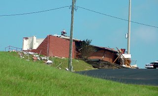
The fieldhouse is not what it used to be...


News crews were on hand.


Television reported that two infants were injured and trapped inside that SUV the previous night.


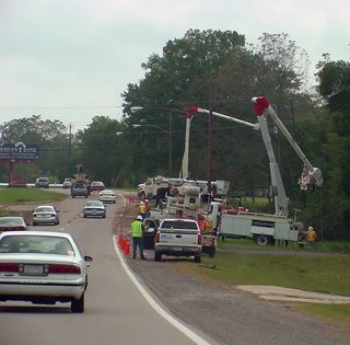
Power crews were everywhere. So were sightseers. This is a huge amount of traffic for Oneonta!


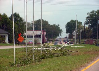
This was the strangest damage. Only the flagpoles in the middle were toppled.


Another view of the former flagpoles.


Was that scratch on the courthouse wall there before?


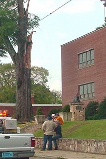
Two huge limbs are missing from this old courthouse tree. I wonder if it will survive. The column supporting the bell was apparently damaged when the limbs fell.


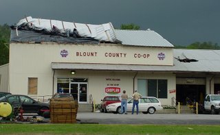
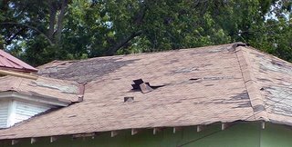
The Co-op roof had a problem.


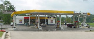
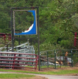
So did their sign. (Note the snapped tree also.)


More roof damage.


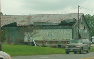
I'm not sure if this building was still in use or not.


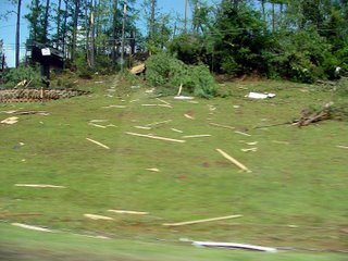
Lot of this kind of thing in the area.


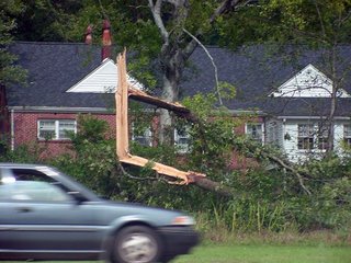
This was atypical tree damage.


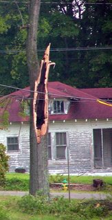
Most were like this -- as if they'd been twisted off. I believe this is characteristic of tornadic winds.
Updated: I've been told that strong straight-line winds can have the same effect.


This one looked like had a problem already.

We didn't make it down the side streets, which were alledged to have the most damage... We didn't want to get in the way of the cleanup.

Update: Preliminary reports from the National Weather Service indicate F2 tornado damage (113 to 157 mph winds) in Oneonta.

The Search for Hawksbill Church

Monday afternoon (November 2nd) found me back in Shenandoah County, Virginia - specifically Strasburg, Edinburg, and Luray - in search of that elusive church mentioned in my previous post!

On Wednesday (October 25th) I had made a detour from Shenandoah National Park to Luray, known for its caverns. But that isn't why I went there. I stopped at the library and got some assistance from one of the librarians. I was looking for the location of what in the 1700s and early 1800s was known as the Hoxbiel or Hawksbiel or Hawksbill Church. By 1848, when a new brick building was constructed, it was known as Mount Calvary Lutheran Church. The librarian provided a copy of transcriptions of the church register of baptisms and marriages but it was for a much later time period. But in the preface I learned that even though the congregation disbanded in 1959, the church building still existed and that it was located three miles south of Luray. However, none of the library staff knew where it was located.

The first two pastors that served the Hawksbill congregation were J. C. Stoever (Sr) from 1733-34 and J. C. Stoever (Jr) from 1734-42. They were Johann Caspar Stoever and were my 6th and 5th great-grandfathers, respectively. As stated in the previous post mentioned above, the elder man died at sea in 1739 while returning from a fund raising trip to Europe. The younger Stoever was a traveling pastor visiting and serving several congregations, often at the same time, in Pennsylvania (primarily in what was then Lancaster County, which encompassed a great deal more territory than it does today) and northern Virginia. Much has been written of his exploits and troubles regarding his pastorate and conflicts with his fellow clergymen. There is no way that I can possibly condense it all down so it would make sense in a brief blog post. A fairly complete accounting of his life can be found on pages 51-101 in "Stover-Stoever-Staver- Stiver, An Account of The Ancestry and Descendants of Johann Caspar Stoever of Pennsylvania" by Vernon Stiver & Patricia R. Donaldson, Saline, Michigan, 1992.

The fact that the two Stoevers were both pastor of this church was interesting but not too surprising given the fact that it wasn't all that far from Madison and the Hebron Lutheran Church, albeit on the other side of a mountain range! But what intrigued me more was the fact that another ancestor, 5th great-grandfather, Wilhelm Georg Forster aka William Foster, served as the eighth pastor of the Hawksbill Church from 1798-1806. The Stoevers are ancestors on my Dad's side of the family and William Foster is on my Mother's side.

I took the main road south from Luray (Business Route U.S. 340) thinking there might be a sign pointing the way. I got excited when I saw a sign for Hawksbill Primitive Baptist Church, until it sank in that it was a Baptist Church! I did stop at a gas station along the way, but no one there knew anything about Mount Calvary Lutheran Church, which wasn't surprising since it had closed in 1959. For another hour, I aimlessly drove along the back roads of the valley, hoping for some good luck but finding none, and not finding the church.

While staying with my aunt that weekend I spent some time at Panera Bread using their free WiFi (thank you very much – my aunt has dial-up access, sloooow) and found a pdf file which is an application for the National Register of Historic Places and which provided an exact location for Mount Calvary Church. I really wasn't concerned with finding the actual church so much as just wanting to see where it was located. The building itself held no meaning for me since it was built long after the Stoevers and Fosters were there.

To make a long story short, I returned to Luray after I left my aunt's place and found the church, sort of. I briefly saw the building through the trees high on a hill at the base of a mountain on a narrow, winding dirt road where there was no place to stop without blocking the road completely. I did see a dirt road (more like a trail) that led up the hill, but it was deeply rutted and overgrown and there was no way I was going to attempt to drive my van on it. I also chose not to walk up the trail since it was rather remote and rugged terrain. And I didn't get any pictures either. But I did satisfy my curiosity. It was really out in the middle of nowhere. Now and even moreso back then.

While pastor of Hawksbill, Wilhelm Foster also served as pastor of the Hebron Lutheran Church in Hampshire County, Virginia (now part of West Virginia) from 1797-1803. It is located on West Virginia route 259 between Capon Lake and Intermont (Photograph on wikipedia). And yes, I did make the drive and went to see where this church was located.

In 1796, Wilhelm Forster had purchased 289 ½ acres of land located on the "drains of Bauman Mill Run" outside of Strasburg, Virginia. It was from this central location that he served these two congregations. Strasburg is located midway between the Shenandoah and Blue Ridge Mountains, just below the northern end of Massanutten Mountain, which divides the Shenandoah Valley.

To get to Hawksbill he had to go over a portion of Massanutten. To get to the Hebron Church in Hampshire County, he had to cross over the Shenandoah Mountains. Both churches are about a distance of 25-30 miles from Strasburg. Over the mountains, through the rivers and forests. A distance that took me far less than an hour to travel probably took him several days. By spending the time to drive through the valley and over the mountains to locate the churches, I gained a greater appreciation for these pioneer ancestors.

Oh, and I also obtained the signature of Wilhelm Georg Forster. It was on the land record where he and his wife Magdalene were selling the land they had purchased in 1796. (Shenandoah County Deed Book Q page 43) They sold the land on July 4, 1807 prior to their move to Fairfield (now Perry) County, Ohio. In 1805 Wilhelm had been appointed as a traveling preacher in the Ohio district known as "New Pennsylvania" which included Fairfield (Perry), Muskingum, Pickaway and Ross counties.

Friday, September 27, 2013

Attack!


I can't help it. Her tail was just too temping. I had to jump on it.

Thursday, September 26, 2013

Grandma Anna's Pfeffernusse

This post was written by Annie in Austin for her Transplantable Rose blog.


When I was a child, my grandmother made pfeffernusse cookies. My younger brother liked them better than I did, but he also liked licorice - which I hated. Anise may not be quite the same as licorice, but the flavors and scents were similar enough to turn me off. And pfeffenusse were hard! No wonder the nickname was Pepper Nuts. Adults liked them with coffee but the children preferred chocolate chip cookies.

We didn't have the recipe after Grandma Anna died so my mom tried recipes from cookbooks and the kind of pamphlets that were often passed out with ingredients bought at the store. The results were okay, but they didn't have the same texture as the adults remembered. Years went by and Anna's grandchildren grew up to have homes of their own.


One year my sister Josie hauled Grandma's old cabinet-style treadle sewing machine up from our parents' basement, wanting to clean & polish it and give it a place of honor in her home. After a stuck-shut drawer was opened, Josie discovered a cache of silk and cotton embroidery threads, along with a tattered yellow newspaper clipping with the recipe for the pfeffernusse.


Josie kept the threads but the clipping was turned over to me - by that time I loved to bake for the family and I'd also learned to enjoy the flavor of anise.My dad and uncle gave the Pepper Nuts a thumbs-up after tasting them, agreeing they tasted like Grandma's.

There was no clue on the paper to tell us where Grandma got the recipe or how old it was, although we're sure it was in use before the mid-1950's. In a few weeks I'll use this recipe again, to bake and pack and share the cookies with my far-flung family.


PFEFFERNUSSE AKA PEPPERNUTS


Heat together until blended:
1/2 cup molasses ( I use dark full-flavored)

1/2 cup light corn syrup

3/4 cup brown sugar

1/4 cup lard (the original recipe called for lard but I always substituted vegetable oil.)


Cool the mixture for 45 minutes. Add 1 beaten egg*.

Combine the following spices and stir into the molasses mixture:


1/2 teaspoon cinnamon

1/2 teaspoon powdered anise (or 1 and 1/2 teaspoons anise extract)

1/4 teaspoon ground cloves

1/4 teaspoon allspice

1/8 teaspoon ground black pepper

Sift together 3 and 1/2 cups flour

1 and 1/2 teaspoons baking powder

1/4 teaspoon baking soda

Mix well. Cover dough and let stand overnight at room temperature.


Roll into 1-inch balls. Bake on parchment paper at 350 degrees F for approximately 12-15 minutes. When cool, roll in powdered sugar. Store in tightly covered tins in a cool dry place for several weeks to mellow the flavor.


* Since the dough sits out overnight I prefer pasteurized eggs for this recipe.


I have a vague idea that some of the dough used to be rolled out and cut with an angel cookie cutter to be tied on the Christmas tree as an ornament. I can remember the angels hanging, but I'm not sure if it was really the pfeffernusse dough or if it was gingerbread dough. Either one should work.


This post was written by Annie in Austin for her Transplantable Rose blog.


Quartzsite and the Trek Rally

As we were leaving theBenson Saquaro Escapee Park a couple stopped and told us that they also had a Trek motorhome and that there was going to be a rally of the Southwest Trek Fun Group. We were going to be in the area so we got the information.

We arrived in Quartzsite - it is an amazing site to see hundreds of thousands of RV's of all sizes and type parked out in the Desert.

There were approximately 68 Treks in our group

Mike and Madeline made a delicious breakfast of waffles with bananas.

Tucson made a new friend - Kobi


video


The weather was good except for this dust storm that blew through.


This is the Hi Jolly monument and cemetery. Haiji Alicame with Camels from Saudi Arabia - Jefferson Davis had approved a plan to import and use camels for freighting in the Arid Southwest as they could carry heavy weight and did not need much water in the desert conditions. They proved their worth but the project was abandoned as the sight of them caused horses and mules to stampede.

After 3 days in the Desert and $3,000 for new Springs, Shocks, Bell Cranks, and front end alignment, we head to Yuma. We decide to boon dock at the Kofa National Wildlife Refuge on our way.

We pick a nice site

We hike to Palm Canyon

Where California Fan Palms, descendants of palms that grew in this region during the last periods of North American glaciation and the only Palm Trees native to Arizona grow in the hills.

Till Later!

Meanwhile, we keep on Trek'n

Melissa, Gary & Tucson

Wednesday, September 25, 2013

Eddie Bauer First Ascent Down Vest?

By Dave Searle


I never used down for insulation until this year. I had survived for years with my €35 Quecha belay jacket so why did I need to spend my beer money on a down jacket? You and I both know the pro's and con's of down over synthetic and it was when I realised that if it was wet in the mountains I'd rather be something else that I realised I should probably start using down. This year I bought my first piece of down clothing, a Rab Microlight Jacket which I have been really happy with and recently I was given a First Ascent/Eddie Bauer Downlight Vest to review for Cold Thistle.


My first impressions were....who or what is First Ascent/Eddie Bauer. Maybe I'm particularly ignorant but I had honestly never seen or heard of this brand before in the UK or even in Chamonix where they have it all. I realised I wasn't that ignorant when all of my mates kept asking where I had got it from. I was really surprised that no one had heard of it as it looked really well made with good materials and features. Why haven't we seen it before? I dunno, I'm just a climbing youth living out the back of my van but if I had to have a go at answering that question it would be that they have a lot of competition over here especially from Rab. So it would seem only fair to write this review with a comparison to Rab's rival product, the Microlight Vest, to get a better understanding of why I genuinely think that Downlight (the First Ascent one) is the better down vest.


Apart from having very similar names and looks this vests actually have very subtle differences in there design and features. First off the Downlight has a higher fill power than the Rab Microlight (800 over 750) which means it will have better loft under outer layers which could give it the edge in warmth although you would proabbly really struggle to notice. I think that the Pertex on the Rab vest is probably better at keeping the wind out but it is heavier than the material the First Ascent has used which is in my opinion more breathable. The Downlight has zips on the hand warmer pockets with a fleece liner which I prefer to the the non-zipped, pertex lined pockets of the Microlight because they do fill with snow if its windy and you can't put anything in them when your climbing, however I have heard this is something Rab is going to change soon. I would have preferred to have seen the pockets on the Downlight slightly higher so you could still use them if its tucked into your harness but I can see why they have put them so low and lazy for a more relaxed feel when your just dossing about town or at the crag. I like that First Ascent offer regular and long fit's for this vest which I have never seen before and given the option I would have gone for the longer cut.


I did have a few issues with feathers coming out to start with but that seems to have stopped now and I think it was probably just the slightly sharper feathers working they're way out rather than an issue with the fabric or stitching.


I am a big fan of my Downlight Vest now. At first I didn't know where it was going to fit into my clothing system but now it comes with me everywhere, mostly as a back up layer, but I have also used this to climb in too which worked really well, keeping my body warm without restricting my arms. It seems to be putting up with some reasonable abuse with little sign of wear which is also impressive for such a light garment.


Even though the Microlight and Downlight are pretty similar I prefer the cut of the baffles around the shoulders which give a less restrictive feel. However Rab have managed to squeeze a chest pocket into the Microlight which I would like to see on the Downlight as its a useful place for me to keep my camera and spare headtorch batteries. If I was stood in the shop with both these vests in my hand I think I would go for the Downlight primarily because of the cut around the arms and the pocket design. With this choice would come with the added benefit of being a bit different to the rest of the Brits you see shuffling about Cham-Town in there Rab kit. I hope I don't get excommunicated from the British climbing fraternity for such a conclusion but screw 'em I'm happy.

Tuesday, September 24, 2013

Forbidden ..

Part III
"More To Go"

It was already lighter when we arrived at the notch. We watched headlamps from a party at the lower basin camp start up to Sahale or Sharkfin. (We never did see where they went.) We wondered if they had noticed our lights on the ridge and what they thought was going on.

Then Steve set about making himself comfortable and took a snooze. I was too uncomfortable to sleep at first and after jostling about in different positions finally took a nap. Steve said I even snored. I awoke a half hour later.

Nap time (photo by Steve Machuga)

Then we watched the sky turn beautiful colors as the sun rose. I ate a bag of dried fruit and nuts and Steve had a few granola bars. We weren't quite ready to get moving, so we lounged until the sun hit a feature we were calling "The Scottish Arete."

Having gotten some rest, we headed out slowly and methodically back down to camp. In our tired condition, we knew there would be a few cruxes on the way to camp. The first was getting around the chock stone at the top of the gully. This proved to be no issue and we were now making our way down the slabs and loose rock. We reached the bottom of the gully and got on the snow. Steve felt comfortable with a standing glissade. I put crampons on and walked quickly down the snow. (I just wasn't feeling confident in the boots I had chosen.)

We got back onto rock in the lower gully and navigated our way down to the next crux. On the way up we made an uncomfortable step onto the slab from a snow lip on the lower snowfield. I was sure there was no way to make this step after the previous day's melting. That would mean we would have a choice of climbing down either of two short waterfalls. When we arrived, Steve probed it out and made a step onto a lower portion of the final slab before making the big step out onto the snow. It didn't look that safe to me so I hesitated before finally making a large gentle step onto the snow. We crossed that short bit of snow and then gained the slabs again before jumping back onto snow down to camp.

Once in camp we quickly went about filtering water to drink. It was nice and cold snow melt and I drank enough to give me brain freeze. We lounged again at the stream dipping our feet in the water and dreading the coming hike out. After a while we made our way back to the tent to pack up and head out.

The flies were horrible at the tent and it made packing difficult. In my already weakened mental state the flies were the final straw. I was running about trying to kill any that came near me. It was an ordeal. We packed as quickly as possible and hoped that once we left the camp area we would be rid of the pesky insects.

Our hope faded as we had to negotiate a grassy moraine littered with Marmot dens and scat. The flies were even worse. There were brief moments hiking down the basin where there was a faint wind or even cooler temps and seemingly no flies. Then we would encounter another area, like the lower stream crossings and be swarmed again.

Once through the stream crossings we made it to the woods and through the avalanche debris fields. Constantly in and out of swarms of flies. At one point during the heaviest bushwhack area of the trail the flies were so thick I looked like Pig Pen from Peanuts with the swarm around me. Steve said he could see dozens landing all over his clothes. When we escaped that area, I told Steve I was close to a nervous breakdown. He said that me running down the trail screaming "Cannot stop! Must keep moving!" was a sign of a partial breakdown. I agreed and knew that the worst was behind us.

About 20 minutes later we were back at the car. We found a note from the rangers on the windshield stating "Steve and Gilbert: Your party has been reported passed due. Please check into the ranger station when you receive this note. A search party is being sent." We packed the car quickly and drank some more water before heading out.

The drive on Cascade River Road always seems longer than it should be. I understand that it is a 23 mile mostly dirt road with a 35mph speed limit, but it just seems to go on forever. Once out, we made right for the ranger station and reported in. We were told someone was just sent out to look for us and we presumed it was the ranger truck heading up the road as we came out. After leaving the ranger station we called our contacts to let them know we were alright. Apparently the rangers had gotten to that first in some cases. Then it was time for the long drive home.

This was another exciting experience in the mountains and was a good learning experience.

I think both Steve and I learned some lessons this weekend:

One of which is that the two of us actually get tired. (Which may be hard for others to believe.) I think if we had not done South Early Winter Spire on Saturday, the Forbidden trip would have played out completely different. We would have been fresh and moving faster without all the lethargic delays. I cannot say for sure this would have kept us on route during the climbing, but it probably would of had us moving faster on route, as well as the approach. It may also have made us more at ease with the rock quality and exposure.

Another lesson has to do with emergency contacts and when to call in a passed due. This was partially a flub because we had changed our plans a few times, so it wasn't exactly set in stone when we left Edmonds. That caused the timing to be off, and created a panic regarding our return time. In retrospect, it appears that Steve and I may not have even been on the same page regarding when authorities should be contacted. While Steve and I had no idea that a rescue was initiated, this incident has made me strongly consider the use of a Spot.

A funny thing about the "rescue" was that when we arrived at the ranger station the ranger behind the desk said they could have initiated the search earlier if we had used the climbing register. (We had neglected to, probably due to our fluid plans.) I thought at the time this was funny as I didn't even think the rescue needed to be initiated at all and that starting it earlier was a waste of time and resources.

The route itself was interesting. I don't know if I'd recommend it, as I was not a big fan of the rock quality. (Well, at least the quality of the protection.) It is also the sort of route people seek for the exposure, which is not a reason I usually seek out routes. There were only a few memorable climbing segments on the route, so it is also not a route to seek out if you want to get into some climbing. However, the setting is hard to beat with numerous 8000' peaks nearby and many small and a few large glaciers tucked here and there. I'd have to admit to loving downclimbing the ridge in the dark as well. It is truly spectacular to be on a beautiful mountain like Forbidden and watch the sun set, the stars rise, and eventually give way to the sun again. It was something we obviously didn't plan to do, but the trip was enriched because of it. It was a wonderful experience that I shall never forget.

I think I learned a few things about my ability to stay alert and focused after being up all of the night. (Partial thanks to Powerbar Gel with Caffeine.) I'll probably always look back on this trip fondly even though the result was not what Steve and I were looking for.

And Steve and I still have not done the West Ridge, so perhaps we'll have to go back for that and see if it lives up to the popularity.

Once again, pics are here.
Tuesday, September 17, 2013

Balanced Ice


This was one heck of a beautiful piece of ice, and it sure was a lot of fun (and a challenge!) to photograph. It was a challenge because it rested atop a 6 foot high pile of plate ice that at it's core was solid ice, but on the surface was not. The surface was lined with loose plate ice anywhere from 1 to 3 inches thick. I had to scramble to the top of this ice pile in order to get this photo with this perspective from my wide-angle lens. It was kind of like trying to climb an extremely steep sand dune... for each step up I slid almost a complete step back down, except this wasn't soft sand. It was cold, hard ice that with each step broke into a million pieces. Eventually, though, I made it to the top of the mound and got up close and personal with this piece of ice. The formation you see here was only about two feet across, and I was only about two feet away from it with my 17mm lens. The way the sky was reflecting within the ice was awesome, to say the least. I sure do love this time of year, it affords countless unique opportunities for photos!

Saturday, September 14, 2013

Emotional Landscapes

Pamela and Patria, Ride Studio Cafe Women's RideTwo days after struggling through a hill training ride last week, I found myself on the bike again - doing what ended up being a 52 mile ride counting my trip there and back. 50 miles seems to be the magic number at the moment: shorter than that and I am left feeling regretful; longer than that and I become more aware of the difference between myself and the stronger riders I am with. Interestingly, I have not gone on a proper ride on my own for over a month: I've met so many cyclists to ride with lately, that I am always with someone. Among the benefits of this is discovering local roads that I've never ridden before - and noticing what an enormous role landscape plays in how subjectively easy or difficult a ride feels.

Riding with theRide Studio Cafewomen last week, we did a loop that on the map appeared near-identical to a route I usually do alone, only along the back roads. The landscape, bathed in the ethereal late-December light, was so stunning that I did not notice the miles or the hills. Where were we? These hardly looked like the tired suburbs I had become so familiar with. Here moss-covered trees grew out of green bogs under cerulean skies. Sleepy farms peaked out coyly from the mist. The remains of frost on dried grass turned meadows into expanses of delicate lace. The sun shone through black, leafless branches, casting high-contrast shadows upon the road. We rode under canopies of fragrant pine trees, which then opened up to reveal enchanted vistas. Climbing one particular hill, I felt such a surge of emotion from the surrounding beauty, that I could not help but go faster. The desire to reach the top and see what more awaited there, made the bike feel weightless.

Roadcycling for me is not about suffering. It is about this emotional connection. Somehow the feel of being on the bike, the sensation of speed, and even the pain in my legs become associated with the reward of seeing an affecting landscape. Once it forms, the association is difficult to break, and it makes cycling addictive - apparently not just for me. Some of my riding partners are experienced racers and randonneurs, and when I listen to them describe rides I notice that they rarely speak of difficulty or pain. Words such as "epic" and "sufferfest" are simply not in their vocabulary. It's not because they don't feel pain and exhaustion, but because they do not consider these sensations to be the point. It's about fulfillment through a visceral connection with one's surroundings. The rest is not important.

Monday, September 9, 2013

Terminated

This is a macabre post, so avert your eyes (or check out this site) if you don't like to think about anything really, really, really cute being injured, shot or killed!

As you can see, we have "Pickles." Pickles is a Cascade Fox. And unless you're an insensitive brute, most people would consider him a very adorable little guy. The problem is, Pickles was so charming, that he attracted a lot of friends, and with those friends came problems. This week, Pickles had to be euthanized (i.e. shot) because he was seriously injured. The general feeling is that he was injured because he was fed by humans.

So the story goes, Pickles was injured (or ensnared) a few weeks ago. Since then, he's been seen pathetically limping around the park near the road between Longmire and Paradise (let me say that this was not a very pleasant sight to witness). No one is sure what it was that exactly injured him, but something did destroy his right front leg. The general thought is that it was probably a vehicle, but maybe a trap. We really don't know. What IS known is that Pickles loved human food and became habituated to humans behavior. With that habituation came problems. The NPS biologist had this to say on the matter,

"After consultation with two wildlife veterinarians, we decided that this animal did not have reasonable prospects for survival in the wild. The leg injury was severe and there was some indication that there was head injury as well. This Cascade fox was fed by people well prior to the injury (even after the injury). Fed animals like this one quickly found that hanging around the frontcountry and roads between Longmire and Paradise was really rewarding. What the feeding public does not understand is that what they do has consequences - some very serious consequences.

This was the third Cascade fox/vehicle collision recorded since 2005. All were fed animals or cubs of fed animals. Vehicle occupants and wildlife are at risk when aimals are fed. Like the old adage with bears - fed wildlife most often result in dead wildlife.

Addressing the park's wildlife feeding problem is a big task that is going to take a while. We've been working to increase awareness of the issue with park staff and visitors but have a long way to go. We're seeking help from social scientists, trying different ways of getting information to the public, and are seeking funding to help reduce the problem. Please help me get the word out.

So here's the word. Don't feed the wildlife! Or...

Sunday, September 8, 2013

Golden Grass


Golden Grass, originally uploaded by ParsecTraveller.

The unusual thing about California is that the state turns green in the winter and become golden in the summer. Well, it would seem unusual to anyone from out of state, but we don't have summer rain that the rest of the nation enjoys. There's been no heavy rain since early April, and there won't be any storms on the horizon again until October.

Most of the grasses that become golden in the summer are actually not from California, but instead originated in Europe. Seeds of these grasses were transported to the state with early Spanish colonists. The result is the popular conception of "the golden hills of California".

Friday, September 6, 2013

Gaitered mtn/ice boots? Batura / Phantom / Ultra


Just for the sake of convenience I thought all these should be in the same place for easy reference.


http://coldthistle.blogspot.com//02/the-scarpa-rebels-part-one-ultra.html


http://coldthistle.blogspot.com//01/scarpa-phantom-ultra-vs-la-sportiva.html


http://coldthistle.blogspot.com//02/new--la-sportiva-batura_14.html


http://coldthistle.blogspot.co.uk//04/scarpa-phantom-guide-vs-la-sportiva.html


6000 specific


http://coldthistle.blogspot.com/search?q=6000


Wednesday, September 4, 2013

Joslin Family :: Grandma Invites Irwin to Visit

North Webster, Ind.
April 6, 1969

Dear Mr. Joslin:

Your most welcome letter received: I have marked my apointment book Aug. 2 and 3 - Irwin Joslin may come here today; I had to use these dates as I work five days a week and the weekend is open and free to entertain you and your family. I do hope you can arrange to be here on these dates as I can show you so many interesting things about your ancestors.

I am enclosing an obituary of your great-gr-grandfather which I found in an old scrap book of Grandma's. You will note that it lists your ancestor as Mrs. Joslin of Okla. I was disapointed that her given name was not used. I told my Aunt Hazlette, about you and she knew all the Elliots here, and as she is now 84 years old she may be able to tell us many things. There is a Robert Elliot in Larwill and she says he is Robert J. Elliots decendent. Yes I know all these people about Larwill. My five children graduated from Larwill High school.

A few years ago I found the 1850 census for Whitley Co. This is in the Ft. Wayne Library and Columbia City Library too. Ft. Wayne has one of the finest geneology departments in the U. S. Hope you can find time to visit there while on your vacation. This is the information I want to share with you:
Census 1850
Lysander P. Joslin age 25
Lydia Joslin 29
Anna E. 5
Mallisa 11 month

James Joslin age 54
Abagail Joslin 45
Edwin 20
Joseph 19
Emily 12
Mary 6
Bela Goodrich 74

Henry Robison age 56
Ann Robison 56
Eliza 22
Henry 17
Emily 15
Elizabeth 10
There are so many ways to find the answers to a lot of things we want to know about these people, but I seem to have so little time to work on it. However, I shall keep at this line now until you come in Aug. in the hope that I can help you. Hearing from you has given me incentive to work harder on this line. I am trying to trace all my ancestors on each branch. All my great grandparents were in Whitley county by 1850 and I am realy having a ball in working on this in my spare time.

=+==+= Some Notes Regarding the Letter =+==+=

I don't know if she wrote more at this time or not. There isn't another letter or page in her files that goes along with this.

The obituary she enclosed was for Robert J. Elliott, father of Luther Joslin's wife, Phoebe Dorcas Elliott. Robert died on December 6, 1893.

Lysander Joslin was found on page 471 of the Whitley County, Indiana census, James Joslin on page 472, and Henry Robison on page 461. No townships were given in the census for that year. Grandma misinterpreted Lydia's age on the census - by comparing other entries on the same page you can see that she was 24 years old, not 29.

Grandma seems to have that age-old problem that most genealogists encounter - not enough time to devote to research!

Other posts in this series:
  • Joslin Heritage Tour
  • Joslin Family :: First Contact
  • Joslin Family :: Grandma Responds to Irwin's Letter
  • Joslin Family :: Irwin's Letter of March 25th

Sunday, September 1, 2013

Mt. Rainier, Disappointment Cleaver


Someone had this crazy idea to climb Mt. Rainier on the 4th of July to watch the fireworks from the top. It might have worked, except it ended up being cloudy on the west side of the state!


We started out that morning and headed up the well worn, normally crowded, DC route. By the time we got above Camp Muir, all the climbers for that day had already come down. We had the entire upper mountain to ourselves! The Ingraham Glacier, Ingraham Flats and Disappointment Cleaver.


David on the nose of DC. Cadaver Gap and Mt. Adams in the distance.


David holding the hand line on the big traverse over to Gibraltar Rock.


David in the crater on the top of Mt. Rainier.


Doug in the crater.


The shadow of Rainier hitting some low clouds at sunset. It was really strange and pleasant to climb that route and not see any climbers above high camp. We did see a few distant fireworks in the Yakima area on our way down. It didn't turn out the way we had hoped, but it was still a great day to try something new on our favorite mountain!